Key Takeaways:
- The implementation of a geofencing system in construction starts with choosing the right solution.
- The process should include thorough staff training.
- The system can be deployed once the geofencing boundaries have been set and the trigger events have been defined.
Construction businesses of today invest in technology that transforms project management and job sites alike.
Geofencing plays a major part in these efforts, and if you’re aware of all its advantages, you’re probably eager to get started.
But understanding what this technology does and how you can ensure you’ll reap its benefits are two entirely different things.
If you don’t want to worry about taking any wrong turns, you’ve come to the right place.
We’ll show you how to successfully implement this technology in 6 simple steps.
Let’s go!
In this article...
1. Choose Your Geofencing Solution
Choosing the right geofencing solution for your business sets the stage for the success (or failure) of your implementation efforts.
Picking the best possible software for you is paramount because this initial choice makes all the difference in the long run.
And because tech-related buyer’s remorse is more prevalent than you think.
Capterra’s extensive survey indicates that over half of the surveyed U.S. businesses regret their software decisions, and that they created a substantial negative impact across several areas.
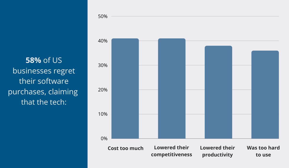
If we take a closer look at these findings, specifically the near-identical percentages of the major listed reasons, we can reasonably conclude that they are interconnected.
While there are many important factors to consider when choosing a geofencing software, such as GPS accuracy and reliability, diversity of geofences, and the extent of collected data, you shouldn’t overlook its ease of use.
This is especially true in the construction industry, where jobs involve numerous stakeholders, not all of whom are tech-savvy.
And if your workers can’t make sense of the technology they’re supposed to use daily, it jeopardizes the entire implementation process.
So how exactly do you recognize user-friendly software?
The intuitive navigation and visually appealing interface are the first clues, but there is more.
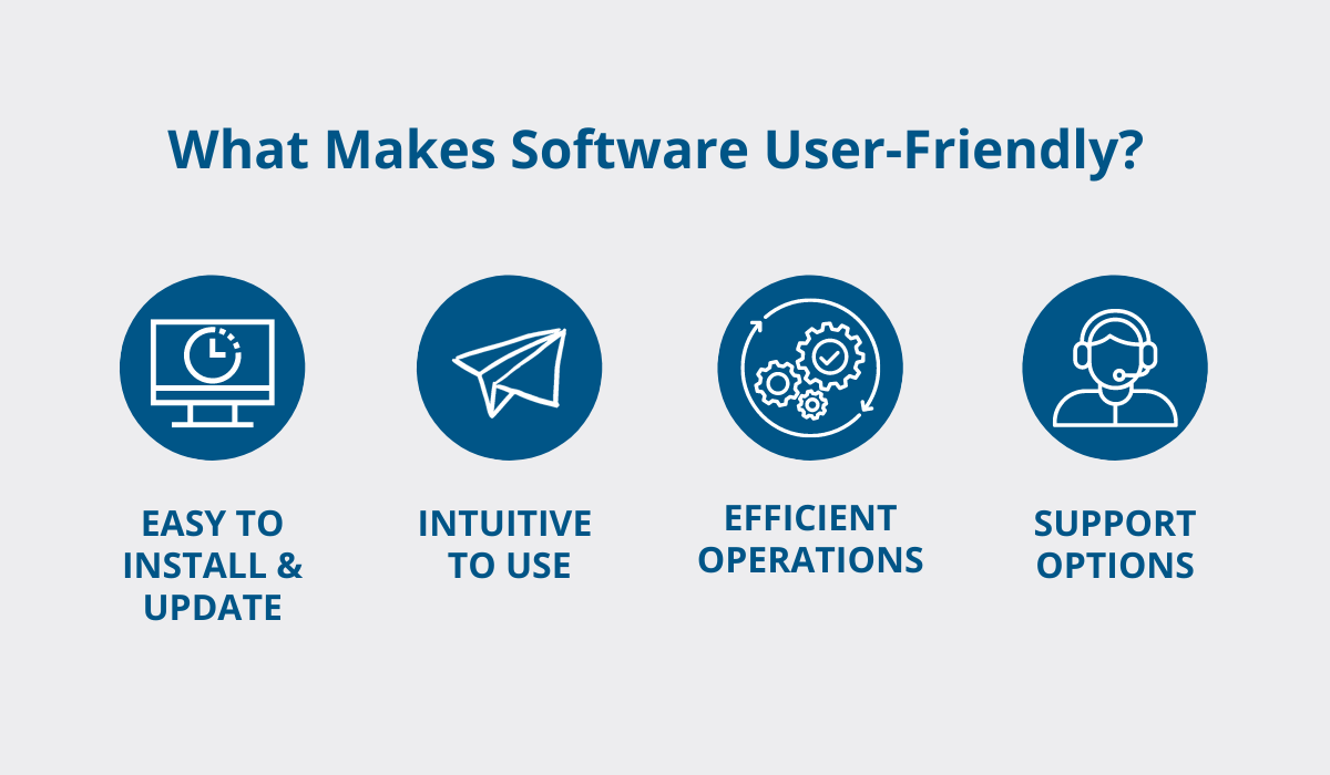
The overall efficiency and extensive support options comprise the core of user-friendly software.
In a nutshell, your solution of choice should enable you to automate certain workflows and integrate various processes in a single source of truth. Efficient operations depend on it.
For geofencing solutions, that calls for a robust, intuitive alerts and notifications system.
The icing on the cake is to have access to fast support that can help you resolve any hiccups quickly.
If your geofencing solution aligns with your company’s needs, and you’ve ticked all the other boxes, you can begin setting up your geofence boundaries.
2. Define the Geofence Boundaries
With a good geofencing solution, setting up virtual fences is a breeze.
However, before you head over to the construction site, take a moment to strategize—after all, geofences can be utilized for many different purposes.
There are several crucial areas where you can set up geofence boundaries, from fueling stations and storage warehouses to restricted zones.
So, will you be covering the entire construction site, targeting some specific zones, or both?
The key is to precisely determine the boundaries based on their primary purpose.
For example, if you want to restrict access to a hazardous area, set up a wider perimeter.
That way, the alert could go off as soon as someone approaches, enhancing safety and minimizing chances of negative outcomes.
On the other hand, a virtual perimeter set around structures with entry and exit points should be defined in a way that matches real-life fences as closely as possible.
And there is a good reason for this.
Rishi Mehra, sector vice president at Trimble, which specializes in construction and geospatial solutions, explains:
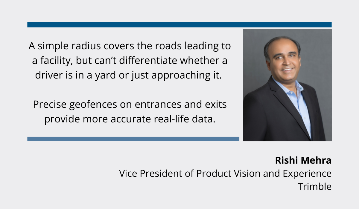
Also, defining precise boundaries enhances data accuracy, while lowering chances of false alarms and unnecessary interventions.
Nevertheless, most of the precision stems from technological advances, rather than the human factor.
Flexible polygonal fences have replaced the older, circular geofencing models, enabling companies to mirror real-life conditions and secure a wealth of actionable data.
Using such advanced technology may seem daunting, but that’s until you see it in practice.
Let’s take GoCodes Asset Tracking, our own asset-tracking solution, as an example.
First, you go to the dashboard, look for the “Geofences” section, and select “Add New Geofence.”
After you’ve pinpointed the exact area on the map, simply choose one of the geofence presets or draw the fence from scratch, and you’re done!
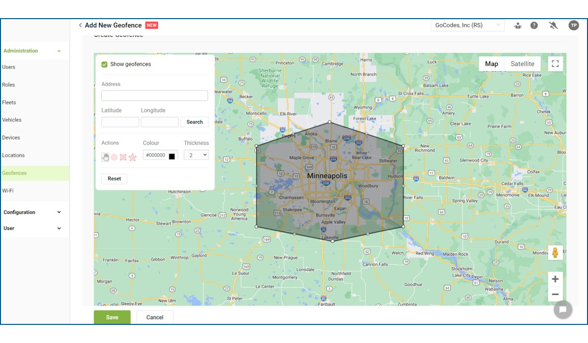
Defining geofences boils down to these simple steps, and the monitoring system works thanks to a combination of real-time GPS trackers, RFID, and Wi-Fi or cellular data.
Deciding what happens when someone reaches a geofence is the next step toward maximizing visibility and control over the construction site processes.
3. Determine Trigger Events
After you’ve defined the precise coordinates of your geofences, you need to specify for each one what happens upon entry or exit and who should know about it.
Because without trigger events, geofences stay silent and can’t provide you with any useful insights.
Trigger events constitute specific actions, based on a simple if-then principle.
You only need to keep in mind each geofence’s intended purpose.
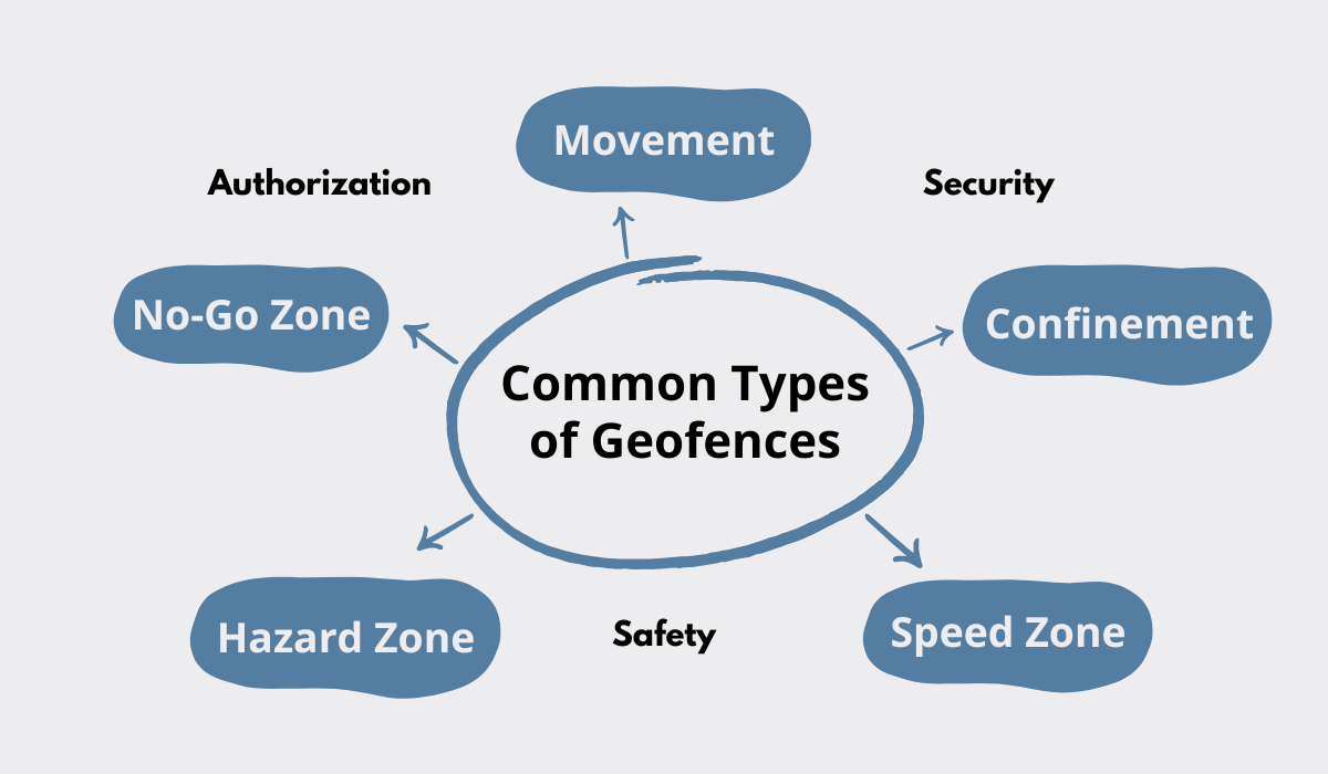
For example, geofences can be set up to track worker movement across the construction site, and be configured in the following way: “If X enters an area, record arrival time.”
Alternatively, if an asset enters the lot at the end of the work day, the action/trigger event that follows can be: “Do a quick maintenance check.”
It all depends on whether you want to confine assets in place, keep non-authorized personnel outside certain areas, or optimize movement routes.
Trigger events are also fairly customizable.
For example, you can set them up to send notifications to designated personnel, determining the number of recipients, the time of notifications, and whether they are received by email or text.
The interface and different alert categories differ depending on the geofencing solution, but they can usually be grouped in the following way:
- Driver
- Environmental Conditions
- Location & Movement
- Maintenance
- Routing
- Safety
- Security
Moreover, a detailed outline of the different functionalities can often be found in the support section of your chosen solution.
Samsara’s software, for example, enables users to choose between a variety of predefined alerts, which are neatly listed along with some helpful configuration notes.
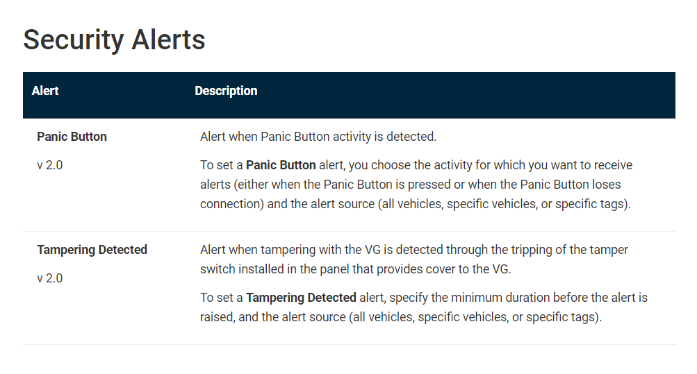
Here, the “Panic Button” alert corresponds to the general loss alert, while “Tampering Detected” raises the alarm about a potential theft in progress.
While the specifics of geofencing software differ, setting up security-related alerts is essential to construction businesses today due to the rise in tool and equipment theft worldwide.
A recent survey by UK-based plant hire specialists Herts Tools revealed several factors that contributed to £17.5 million worth of tools stolen in London in just one year.
Unsurprisingly, their main recommendation centered on introducing robust theft prevention measures.
Once you’ve defined your geofences trigger events, it’s time to make sure all your systems are in sync and poised to deliver results.
4. Integrate Geofencing Software with Your Other Systems
The true potential of geofencing is revealed once it’s fully integrated with your existing systems.
Successful integration of different software is important for any business, but the uniquely complex AEC landscape makes it a priority for construction companies.
Indicators of this priority status are some intriguing findings on digital project management in the US, originally shared by market intel specialists Dodge Construction Network and summarized by Aarni Heiskanen, a construction innovation agent at AE Partners.
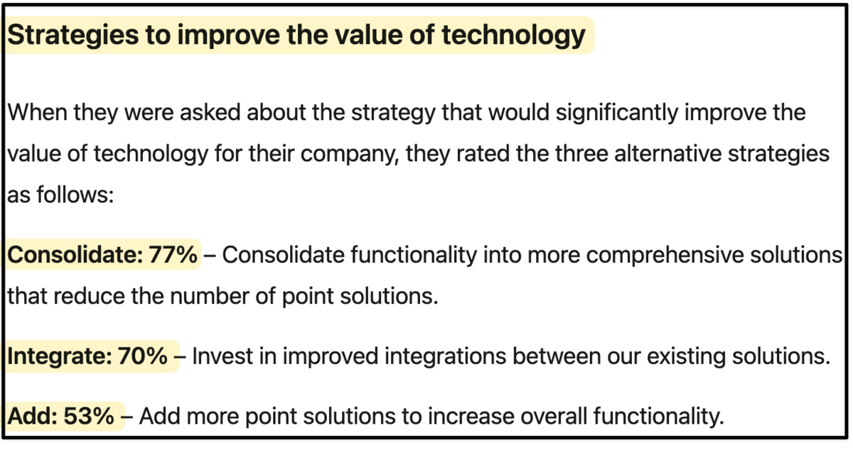
Out of 200 surveyed US contractors, 70% feel that integration is the best course of action for their company to create value through technology.
Seeking and investing in comprehensive solutions is the survey’s highest-rated strategy, and is often considered the most forward-looking approach.
But this doesn’t mean you should take it.
Companies undergoing digital transformation are acutely aware of their current limitations and needs, which is why they’re in the best position to recognize whether they should turn to solutions that enhance their existing system or uproot it.
Luckily, geofencing technology is highly suited to integrating with different systems.
That includes everything from video surveillance and perimeter control barriers, to access points and identification and verification protocols.
The impact of geofencing is equally felt on a wider scale of construction project management, which is why it is crucial to ensure integration with your project management and communication systems.
Most software tools can be connected with others via API, and our GoCodes Asset Tracking is no exception.

There are numerous benefits to having a centralized system, including greater visibility, streamlined processes, and more reliable data.
Such integrated systems also make it easier for your workforce to jump on board with the geofence solution and begin implementing it to its full capacity.
5. Train Your Staff
At the end of the day, the key ingredient of successful software implementation is the people who will be using it.
Therefore, training key staff members on how to navigate the software, define virtual boundaries, and interpret alerts is the final step before deploying your new tech.
For the training to be successful, keep your efforts as people-centered as possible.
Why?
Because there’s a disconnect between executives and staff members on how successfully businesses handle people’s needs when introducing new technologies.
The graphs below illustrate that.
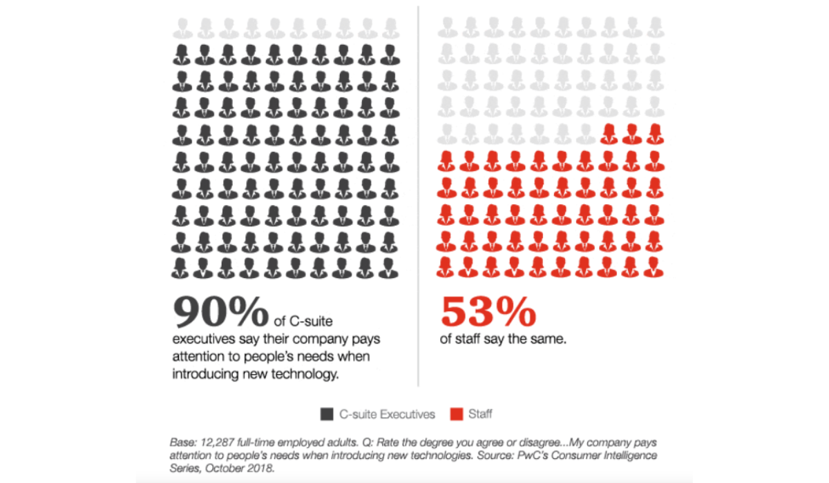
This data comes from PWC’s global survey on tech at work, involving 12,000 employees from multiple industries. Although somewhat outdated, it clearly shows this discrepancy.
Thornton May, the Co-Founder of The Digital Value Institute, underlines the insufficient attention given to those embarking on digital transformation journeys:
“In our contentious times, the ONE Thing that EVERYONE can agree upon is that EVERY Organization, EVERY Executive, EVERY Individual, and EVERY Object is on a digital journey. Sadly, most have no map, no guide, and bad shoes.”
Appearing out of touch and not giving sufficient support can dramatically impact the success of the technology’s adoption, and even destabilize your company’s ecosystem.
Here’s what you need to do to avoid that.
For starters, prioritizing previously mentioned user-friendly solutions facilitates the entire process, and is an immediate green flag for the employees.
Another one is clear and open communication.
Since new software means managing a digital learning curve, define key training objectives and communicate your expectations accordingly.
Moreover, show understanding regardless of the employees’ learning pace and different stages of resisting change.
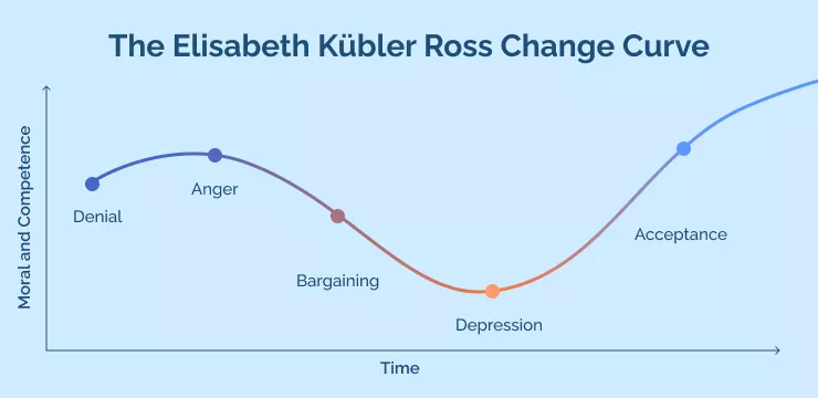
When it comes to the practical organization of training sessions, begin by tackling basic software navigation and features, and gradually introduce key scenarios and appropriate actions based on different trigger events.
Both managers and more tech-savvy employees can provide guidance and give relevant input, but offering a range of useful resources will encourage self-learning further.
Once you’re satisfied that both the system and the people are ready to implement changes that boost efficiency, security, and safety, you can move on to the final stage.
6. Deploy the Geofencing System
Here we are, the most exciting part of the journey!
By deploying the system across the entire construction site, you’ll be poised to collect valuable data and use it to optimize ongoing processes.
Although it’s tempting to sit back and let the system do what it does best, analyzing data and keeping an eye on any potential issues comes first.
You might have dozens of activated geofences, so it’s important to observe each one individually and modify them if necessary while keeping in mind their joint impact on the job site.
One of the major advantages of geofencing systems is access to vast amounts of data, which equips construction companies with the necessary tools to counter negative data-related practices in the industry.
Namely, research by FMI Capital Advisors reveals that over 95% of data is lost across engineering and construction industries.
This is all the more shocking considering the risks involved in making decisions based on unreliable or limited data.
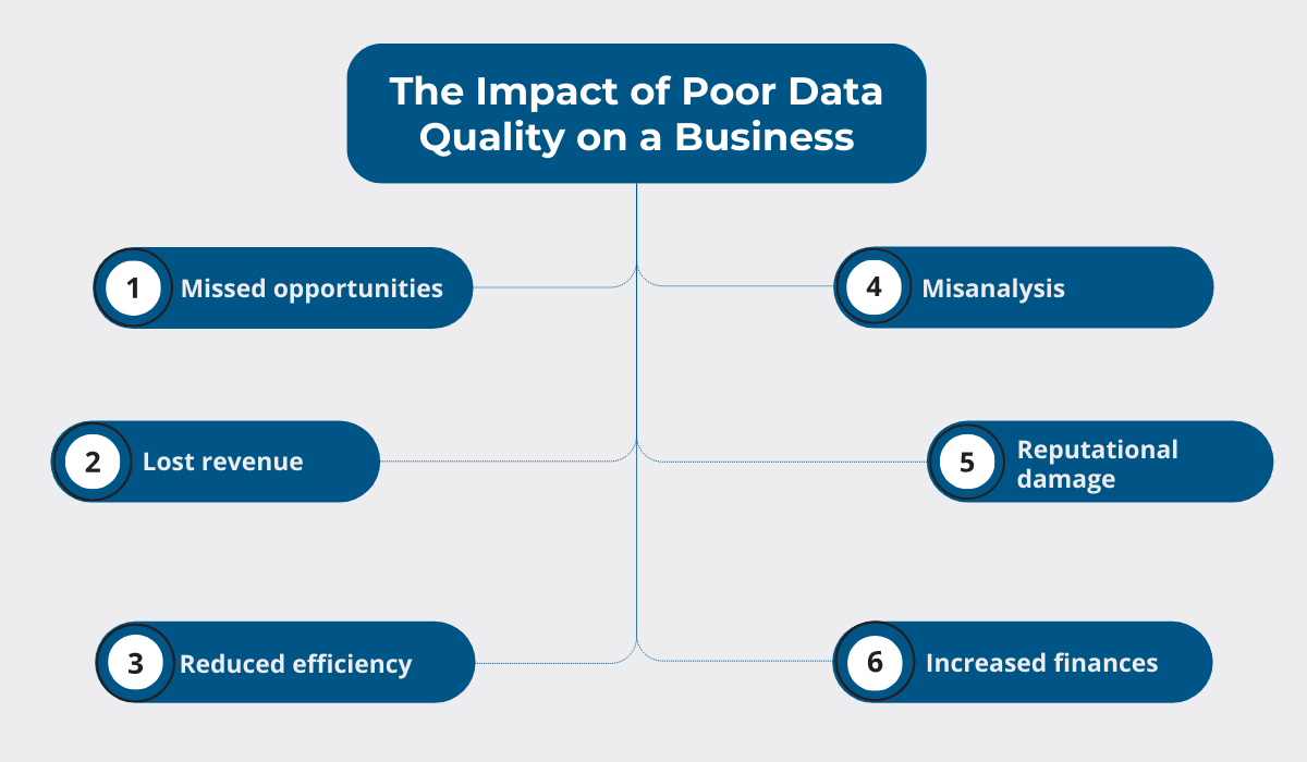
On the other hand, regular data analysis allows you to cut down on costs by allowing you to identify harmful trends, map areas for improvement, and seize new opportunities.
And since one of the main geofencing benefits revolves precisely around its data-generating capacities, most solutions offer extensive reporting abilities that can assist you in introducing much-needed changes.
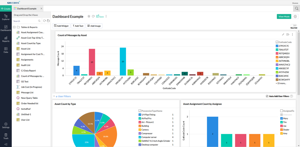
The collected data forms the basis for powerful fleet and equipment management.
With geofencing data, you’ve secured the ability to anticipate site-wide issues and act proactively in resolving them.
With that, success is sure to follow!
Conclusion
Taking the time to complete these six steps and bring geofencing technology to your construction site enables you to make confident business strides for years to come.
The road between choosing your geofencing solution and deploying it may feel long and winding, but your best allies are careful planning, meticulous testing, and employee-centered management.
Although every digital transformation story is different, we trust that this piece helped you prepare for the road ahead.

