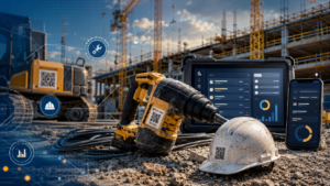
Geofencing is a technology that enables you to set up virtual fences around areas like construction sites or material and equipment storages to monitor activities within them.
You track who and when enters and exists the defined area, and that gives you some significant benefits—you can ensure the security of your assets and improve worker safety, but also monitor equipment, materials, and people to optimize resources and make more informed decisions.
And you probably already know that, so you’ve decided it’s time to use geofencing on your construction site.
Now, the crucial question arises: which geofencing solution suits your needs best?
Join us today as we explore the top 7 geofencing software options you should know about and choose from to streamline operations on your construction site.
Let’s dive in!
In this article...
GoCodes Asset Tracking
We are starting with GoCodes Asset Tracking—our very own solution designed to revolutionize asset tracking in the construction industry.
While GoCodes Asset Tracking isn’t solely focused on geofencing, we’ve seamlessly integrated this feature into our robust software.
After all, effective asset tracking and geofencing go hand in hand.
And with GoCodes Asset Tracking, tracking your assets is now simpler than ever.
Our system equips you with QR-coded labels to effortlessly tag your tools and equipment for easy identification.
Plus, scanning these QR codes via scanners or smartphones grants instant access to their location and usage details on our cloud-based platform.

For your most prized possessions, such as vehicles and heavy equipment, we offer real-time GPS trackers.
These trackers provide minute-by-minute location updates, ensuring you’re always informed about the whereabouts of your assets, whether they’re on-site or in motion.
Additionally, they record crucial metrics like engine hours and vehicle speed, empowering you with comprehensive fleet management capabilities.
So, it’s straightforward: with GoCodes Asset Tracking, you’re not just tracking assets; you’re optimizing your entire operation.
But here’s where it gets really exciting—our geofencing feature.
In our GoCodes Asset Tracking app, you can define specific areas on the map, such as project sites, and set up virtual boundaries, or geofences, around them.
You can adjust their shape and size in a few clicks to fit the areas you want to monitor, like this:

If any of your equipment moves beyond these boundaries, GPS trackers alert GoCodes Asset Tracking software, and GoCodes Asset Tracking will notify you instantly.
It’s like having an extra set of eyes watching over your assets, giving you peace of mind and enabling swift action in case of unauthorized movement.
And the benefits of this technology are far-reaching:
- improved site security,
- easier equipment recovery,
- increased accountability,
- better asset utilization, and many more.
As you can see, GoCodes Asset Tracking is a comprehensive system designed to secure your assets and provide visibility into their whereabouts.
With seamless integration of asset labels, GPS trackers, and geofencing features, GoCodes Asset Tracking eliminates the need for multiple vendors and technologies, offering you a more streamlined solution for efficient asset management.
As for pricing, our plans are tailored to accommodate varying asset quantities and user logins.

You also have the option to add real-time GPS trackers as a separate module, ensuring you only pay for what you need without exceeding your budget.
And with our 15-day free trial, you can experience the full potential of GoCodes Asset Tracking firsthand before making any commitments.

HCSS
Heavy Construction Systems Specialists (HCSS) Telematics is a comprehensive GPS solution tailored for the construction industry.
Imagine being able to track the location and performance of your entire fleet in real time, whether using HCSS GPS devices or OEM-installed devices.
HCSS Telematics enables just that, giving you visibility and control over your assets.

But what sets HCSS Telematics apart is its powerful geofencing software.
Hear it from Dispatcher Hanes of E.K. Services, Inc., who relies on HCSS Telematics’ geofencing to ensure precise asset tracking at all times:
“The first thing I do when dispatching equipment to a new site is establish a geofence so we always know exactly where everything is—and get alerted if anything is unexpectedly moved.”
However, unlike many other systems that limit you to rectangular geofences, HCSS allows you to draw geofences that accurately map your current job site.

This precision enables you to:
- log entry and exit times more accurately,
- track total hours on the job,
- and optimize equipment usage.
HCSS’s integration with HeavyJob, a job management solution, streamlines operations further, automating equipment hour population on time cards and identifying inefficiencies effortlessly.
Then, dynamic geofences also enable precise capture of asphalt cycle time and equipment transport tracking, enhancing efficiency on construction projects.
Finally, the newly introduced Location Details view provides real-time status data for all HCSS Telematics locations, including geofences.
In other words, you can always gain insight into fuel levels, fault codes, and runtime hours for equipment within the geofence.
As for pricing, Software Advice indicates that HCSS Telematics starts at a competitive rate of $11.00 per month per equipment.
However, the pricing is not visible on their site.
To get pricing customized to your specific requirements, you would need to fill out a form on their website and contact them directly.
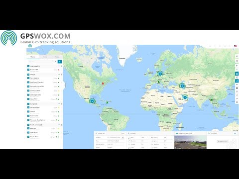
GPSWOX
Like many others on this list, GPSWOX is a robust GPS fleet tracking and management software designed to streamline fleet operations and enhance security.
With GPSWOX, you gain access to a myriad of features to meet the needs of modern fleet managers:

This software is compatible with more than 900 GPS trackers, and it also allows seamless integration with any new or custom GPS tracker of your choice, ensuring flexibility and adaptability to your specific requirements.
On top of that, this software is translated into over 30 languages, so it’s not surprising that it is used in more than 120 countries.
One standout feature of GPSWOX is its geofencing capability.
Just like other tools on this list, the GPSWOX geofencing feature enables you to set up geofences and allows you to receive real-time notifications whenever a vehicle or employee enters or leaves the predetermined area.
You can customize these notifications to your preferences, whether it’s a sound notification on your web browser, push notifications on mobile apps, email alerts, or SMS messages.
Setting up a new geofence with GPSWOX is straightforward. Simply name the geofence, choose its color, and start drawing on the map, as you can see in the video below:
You can easily edit the geofence anytime to suit your changing needs.
Additionally, GPSWOX allows you to import and export geofences, making it effortless to manage hundreds of them if necessary.
When it comes to pricing, GPSWOX offers a pay-for-what-you-need approach.

Depending on the number of objects you track, you can choose between a Lifetime License or a Monthly Plan, with additional add-ons available to customize your plan.
They also provide a 30-day free trial to test all the features, including geofencing.
ASCEND
ASCEND, with its motto “Track anything. Optimize everything,” offers a comprehensive fleet management software solution, complete with a geofencing feature.
This versatile platform allows you to track assets, people, and processes through a single platform, ensuring efficient management of your entire fleet.
With ASCEND, setting up virtual perimeters takes just a few taps on a map.
These geofences trigger entry or exit alerts, providing a real-time view of vehicle and asset usage.
By analyzing this data, you can identify inefficiencies, optimize resource allocation, and ensure assets are where they should be.

Geofencing with ASCEND offers a range of benefits:
- Track fleet activity at job sites and service stops to reallocate resources for maximum productivity.
- Log arrivals and departures for accurate billing and payroll, and identify operational bottlenecks.
- Define customer locations for precise ETAs and delivery notifications, and establish driver territories for streamlined operations.
- Detect off-route travel or stops and receive alerts to correct driver behavior.
- Set up zones off-limits to certain vehicles and assets, restrict speeds, and ensure safe and authorized use.
However, ASCEND’s website lacks detailed information on geofence customization, as well as pricing.
Still, another standout characteristic of this software is its dedicated customer support team, which has been praised by numerous users on Capterra.
All in all, ASCEND’s comprehensive fleet management solution, geofencing capabilities, and exceptional customer support make it another valuable tool for protecting your construction sites and maximizing the efficiency of your construction operations.
GreenRoad
Next on the list is another telematics solution with geofencing capabilities—GreenRoad.
Combining app, hardware, safety platform, and video telematics, GreenRoad provides comprehensive driving data to enhance fleet safety and driver behavior across various industries, including construction.

GreenRoad uses real-time coaching, predictive AI, and advanced fleet analytics to improve driver safety and reduce risks.
For example, with GreenRoad, drivers can receive real-time in-vehicle feedback, fostering safer driving practices.
The platform’s dashboard offers users key performance indicators, charts, and reports, delivering actionable insights into every fleet driver, vehicle, and trip.
Geofencing with GreenRoad is also seamless and efficient.
Below, you can see the process of setting up geofenced areas and landmarks through the GreenRoad portal:

Once you set up geofenced areas and landmarks through the GreenRoad portal, you can gain various capabilities to improve fleet management, such as monitoring entry and exit and detecting unauthorized usage, and more:

Although pricing details are not available on their website, GetApp indicates that GreenRoad’s pricing starts from $12 per month per feature.
Despite this, GreenRoad’s comprehensive features and innovative solutions make it a valuable asset for businesses that want to optimize fleet management and, above all, enhance safety.

Verizon Connect
Verizon Connect is a comprehensive fleet management solution with advanced geofencing features designed to optimize operations and bolster security.
By leveraging custom geofences, you can effortlessly create virtual perimeters around key geographic areas, enabling precise tracking of job site visits, duration, and frequency.
Plus, the software provides intelligent suggestions to correct incomplete geofences, ensuring accuracy and effectiveness.

One standout feature is the innovative suggested geofences, which automatically identify frequently visited GPS locations.
This allows you to monitor all areas visited by your vehicles throughout the day, empowering you to identify unauthorized visits and potential inefficiencies.
Moreover, you can swiftly set up new geofences around these areas to enhance security and operational efficiency.
Discover how this feature has transformed fleet management for one of their clients in the video below:

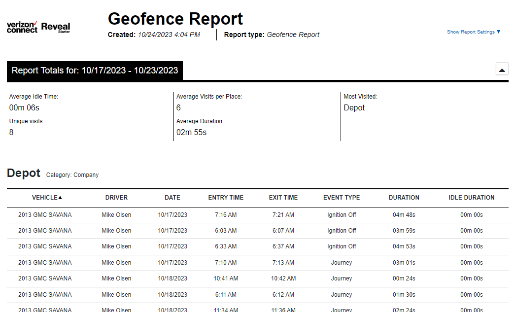
Another robust feature of this tool is the detailed reporting of activities within geofences.
From location visits to stop details and travel times, you can access both historical and real-time data on your vehicles and drivers’ behaviors.
This is invaluable for making informed decisions and optimizing your operations for peak efficiency.
When it comes to pricing, Verizon Connect’s pricing data is unavailable on their site, and you must contact them directly.
However, Tech.co reports that Verizon Connect’s Reveal solution starts at $23.50 per month per vehicle, with customizable packages based on specific features.
A free demo is also available, and Verizon’s hardware comes with a factory warranty.
EquipmentShare
Last on our list is EquipmentShare and its T3, the operating system for construction.
T3 is a suite of apps designed to digitalize construction operations.
With T3 Fleet, you can connect all your tools, trailers, vehicles, and machines, regardless of make or model, and gain a comprehensive real-time view of your entire fleet’s health and usage.
Geofencing is a feature within the T3 Fleet app.
This feature lets you draw borders around your active job sites, providing crucial insights into the people, assets, and materials within each boundary.
As in other tools on this list, geofencing:
- keeps you organized,
- enhances equipment utilization tracking, and
- reduces the risk of theft.
This tool, too, enables you to receive real-time alerts when assets enter or exit job sites.
You can also set up alerts for when a machine exits a geofence or is being operated outside of regular working hours.
Then, through their Fleet app, you can track your equipment’s GPS location in real-time and provide law enforcement with accurate, up-to-the-minute location details.

Furthermore, their T3 Analytics generates insightful reports on the equipment within your geofences, allowing you to optimize fleet management by identifying asset utilization patterns and potential opportunities for improvement.

For instance, you can efficiently allocate resources by relocating machines from idle projects to sites in need, thereby reducing rental costs and maximizing resource utilization.
Regarding the pricing of this tool, you will have to contact EquipmentShare directly.
All in all, EquipmentShare, with its T3 system and geofencing feature, is yet another valuable software on our list of top geofencing software to use on construction sites.
Conclusion
This brings us to the end of today’s exploration of top geofencing software to use on your construction site.
As you have seen, most of these solutions are, in fact, asset tracking or fleet management software, with geofencing playing a crucial role in enhancing these processes.
Geofencing simplifies asset tracking and management by defining safe zones, making the entire process more efficient and secure.
The key takeaway is to choose a solution that offers comprehensive features and robust geofencing capabilities to meet your needs effectively.
Ensure the solution you select aligns with your requirements for asset tracking and management, and rest assured, the seven tools we’ve discussed here offer robust geofencing features to support your construction operations.